Get Slidell & St. Tammany News
Enter your email below to get local news in your inbox.

SLIDELL, La. — The threat of flooding is increasing across portions of Southeast Louisiana and the Mississippi Gulf Coast as multiple rounds of heavy rain and thunderstorms move through the region this weekend.
The National Weather Service in New Orleans said early Saturday that widespread rain and embedded thunderstorms will continue through Sunday, with the greatest concern for flash flooding concentrated along coastal areas.
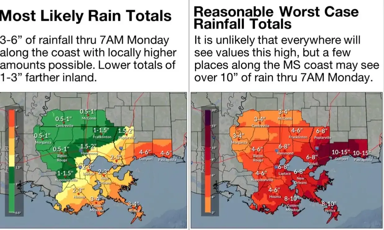
Forecasters expect generally 4 to 6 inches of rain with locally higher amounts along and south of Interstate 10, while coastal Mississippi could receive 6 to 10 inches by Sunday evening.
A Flood Watch is in effect for areas facing the greatest threat, while Coastal Flood Advisories are also posted for portions of the Louisiana and Mississippi coast.
The National Weather Service says its broader reasonable worst-case scenario shows some locations could receive more than 8 to 10 inches through Monday morning. That is not the expected rainfall everywhere, but represents what could occur in areas where the heaviest rain repeatedly moves over the same locations.
What About The Northshore?
The Northshore is expected to see considerably less rain than areas closer to the coast.
Current forecasts generally favor around 1 to 2 inches across areas north of the main front, while heavier totals are expected closer to New Orleans, coastal Louisiana and South Mississippi.
That sharp difference means residents should not interpret the potential 8 to 10 inch totals as a forecast for all of St. Tammany Parish.
However, locally heavy downpours remain possible, and conditions can change depending on exactly where bands of rain develop.
Coastal Mississippi Faces Greater Flooding Threat
The Mississippi Gulf Coast currently appears to be one of the areas most likely to experience significant rainfall.
The National Weather Service said coastal Mississippi could receive 6 to 10 inches, while WLOX is forecasting widespread totals of roughly 4 to 7 inches across South Mississippi, particularly the coastal counties.
Heavy rainfall rates over a short period could produce localized flash flooding and quickly overwhelm drainage systems.
Coastal Flooding Also Possible
Rain isn’t the only concern.
Persistent onshore winds and higher-than-normal tides are expected to produce minor coastal flooding along vulnerable shorelines during high-tide cycles over the next several nights. A Coastal Flood Advisory remains in effect for affected areas.
Residents should avoid driving through flooded roads and should continue monitoring forecasts throughout the weekend as the location of the heaviest rainfall becomes clearer.
The Rabbit Hole will continue monitoring conditions across St. Tammany Parish, Southeast Louisiana and the Mississippi Gulf Coast as the weekend progresses.






How is this affecting you and your neighborhood? Join the conversation below.
Free. Straight to your inbox. Cancel anytime.





Join the conversation — create a free TRH News account to comment.