Get Slidell & St. Tammany News
Enter your email below to get local news in your inbox.

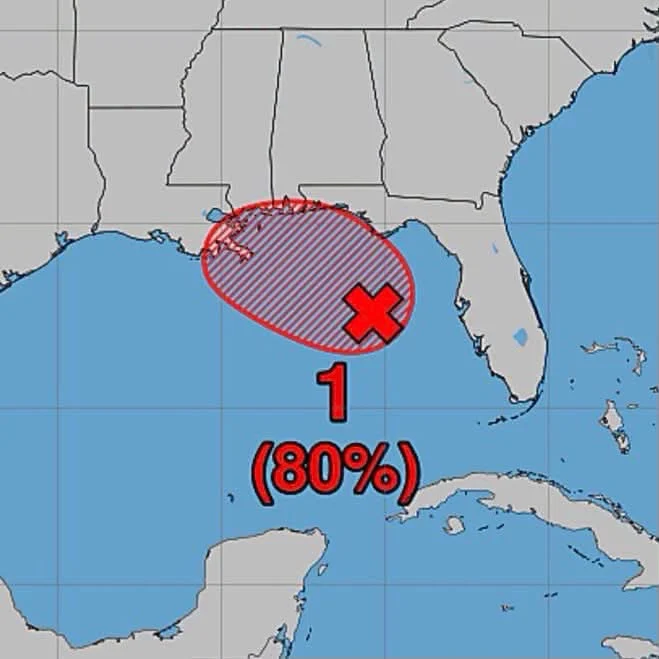
Forecasters are closely watching a tropical disturbance in the northern Gulf of Mexico that now has an 80% chance of developing into a tropical depression or tropical storm over the next several days.
Current forecast models show the system moving generally westward across the Gulf. While it is still too early to know exactly where it could make landfall or how strong it may become, residents along the Gulf Coast, including Louisiana and Mississippi, are encouraged to monitor the latest forecasts.
Even if the system never becomes a named storm, it could still produce heavy rainfall, gusty winds, rough surf, dangerous rip currents, and localized flooding across parts of the region.
Now is a good time to review your hurricane preparedness plans, make sure emergency supplies are stocked, charge electronic devices, and stay informed as new forecast information becomes available.
Meteorologists expect to have a much clearer picture of the storm’s future track and intensity over the next day or two as additional data is collected.
The Rabbit Hole will continue monitoring this system and provide updates as new information becomes available.






How is this affecting you and your neighborhood? Join the conversation below.
Free. Straight to your inbox. Cancel anytime.



Join the conversation — create a free TRH News account to comment.